Naryn · Kyrgyzstan
Kel-Suu Lake
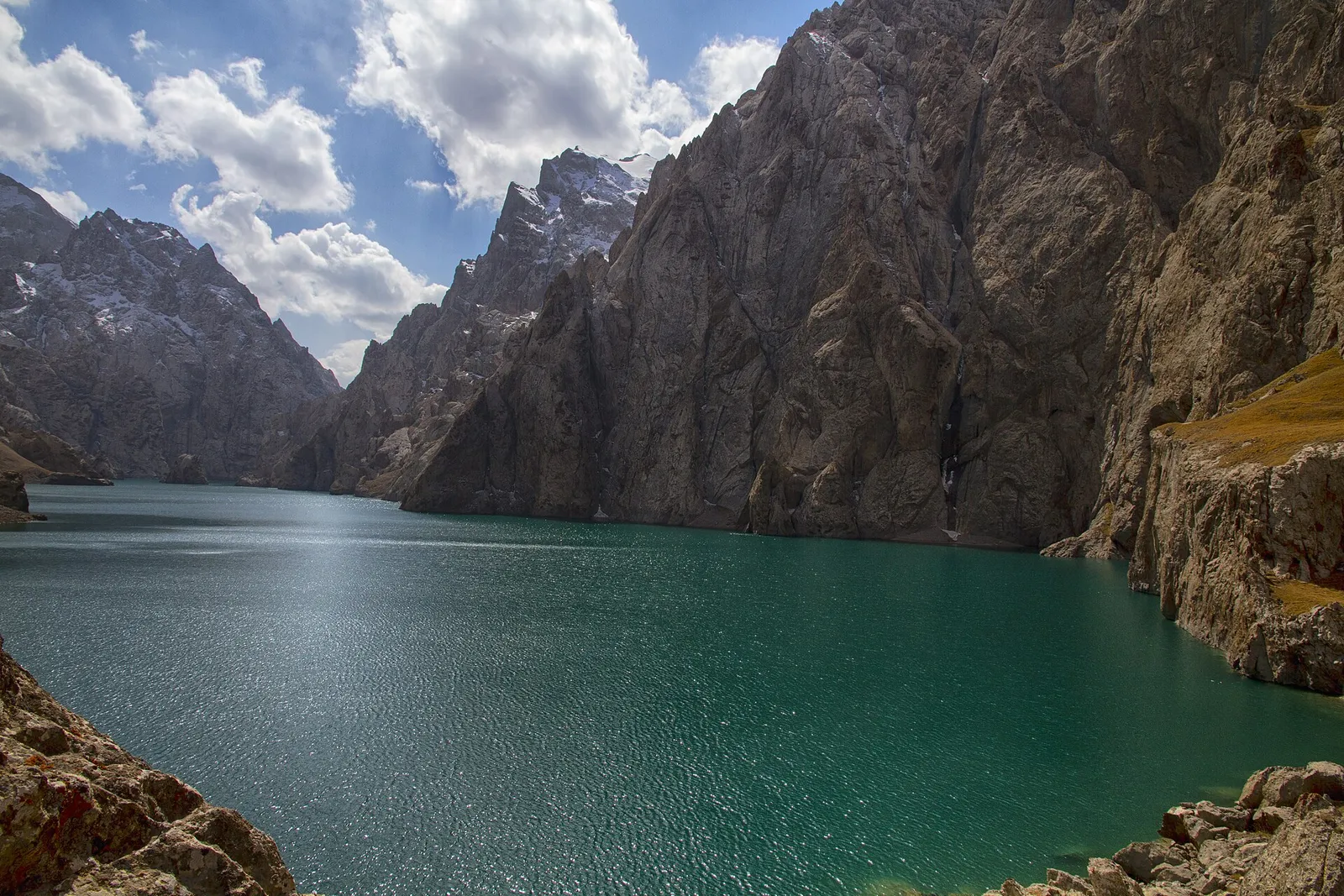
Kel-Suu is an alpine lake at about 3,500 m in the Kakshaal-Too range of At-Bashy district, close to the Chinese border. It fills a steep-sided rocky canyon. Seasonal yurt camps in the Kok-Kiya valley open from late June to early September; from there travellers hike, ride or take a 4x4 shuttle about 7 km to the shore, where boat trips run. The track from Naryn takes five to eight hours by 4x4. A border-zone permit is required and takes one to two weeks to arrange.
- Region
- Naryn
- Altitude
- 3,514 m
- Roads
- 4x4 only
What Kel-Suu is
Kel-Suu is a lake at about 3,514 m in the Kakshaal-Too range, in the south of At-Bashy district close to the Chinese border. It fills a narrow rock canyon, so instead of an open shore there are near-vertical walls dropping straight into the water and side arms you can only see from a boat. The level moves from year to year — water drains away through underground channels and the lake can fall sharply, then fill again.
The border permit
Kel-Suu lies inside a border zone and a permit is compulsory, for you and for your driver. A military checkpoint stands just beyond the Kayyndy pass. Only the stamped paper original is accepted there; photographs and copies are turned away. Agencies and community tourism offices arrange permits, and processing runs from about five working days to ten, so apply two to three weeks before you travel. A permit is normally valid for around a month.
Getting there
The usual route leaves Naryn through At-Bashy and Ak-Muz and crosses the Kayyndy pass (about 3,340–3,400 m) into the Ak-Sai and Kok-Kiya valleys: roughly 150 km, but five to eight hours in a 4x4, with river fords where the water can rise above the floor of the car. From At-Bashy it is about 105 km and five hours. If Kayyndy is still under snow, the way round runs along the Torugart highway past Chatyr-Kul — about 120 km of gravel and another five hours.
Reaching the water
Vehicles stop at the yurt camps in the Kok-Kiya valley. The shore is a further 7 to 12 km depending on the camp: two to three hours on foot, quicker on horseback, and some camps run a 4x4 shuttle. Boatmen at the lake take visitors along the canyon.
Season and where to sleep
The window is short. Camps open from about late June and most close in early to mid-September. Accommodation is seasonal yurt camps in Kok-Kiya, with meals included. There is no mains power, mobile coverage is unreliable, and nights at this altitude are cold — bring cash and a warm sleeping layer.
Good to know
Questions travellers ask
- Do you need a permit for Kel-Suu, and how long does it take?
- Yes, a border-zone permit is compulsory, for every traveller and for the driver. Agencies and community tourism offices arrange it and processing takes roughly five to ten working days, so apply two to three weeks before the trip. A permit is usually valid for about a month. Without one you will be stopped at the checkpoint and turned back.
- Is a photo or copy of the permit enough at the checkpoint?
- No. The military checkpoint past the Kayyndy pass accepts only the stamped paper original. Photographs on a phone and printed copies are refused, which means the document has to be collected before you set out — usually in Naryn or Bishkek. Carry your passport with it, and make sure the driver has a permit too.
- How long is the drive from Naryn to Kel-Suu?
- About 150 km, but five to eight hours in a 4x4. The route goes through At-Bashy and Ak-Muz, over the Kayyndy pass at roughly 3,340–3,400 m, then down into the Ak-Sai and Kok-Kiya valleys. There are river fords along the way where the water can rise above the floor of the car, so the timing depends on conditions.
- When is Kel-Suu accessible?
- The realistic season is from late June to mid-September. Earlier, the Kayyndy pass is often still under snow and the fords are high with meltwater; later, the yurt camps close. If the pass is blocked there is a longer detour along the Torugart highway past Chatyr-Kul, about 120 km of gravel and five more hours.
- How do you get from the yurt camps to the lake itself?
- The camps are in the Kok-Kiya valley and the lake is a further 7 to 12 km depending on which camp you stay at. Walking takes two to three hours each way; horses can be hired at the camps, and some run a 4x4 shuttle part of the way. Boatmen at the shore take visitors into the canyon arms of the lake.
- Where do you sleep at Kel-Suu?
- In seasonal yurt camps in the Kok-Kiya valley, run by local families and open only for the summer, normally with dinner and breakfast. There is no village, no mains electricity and no shop, and mobile coverage is unreliable. Bring cash, a warm sleeping bag or extra layer, and anything you cannot do without.
Kyrgyzstan
More places
Your route is one conversation away
Tell us your dates, your pace and what you would like to see. We will put together a route from our own suppliers.